


Hi! Come on inside… it’s toasty! www.toastymobilesaunas.com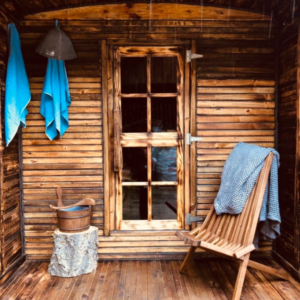
Here, our hospitality is warm, and our saunas are hot! At Toasty we love to pamper our guests so that no matter how long their time with us, they leave feeling refreshed, revitalized, and longing for their return visit. Whether you are looking for a quiet retreat, or an opportunity to reconnect with friends and family, we can’t wait to host you.
Our traditional wood-fired saunas are hand-built and unique to Toasty. We have taken special care to design our saunas to be warm, rich, and inviting. Our smaller 6pp sauna is toasted in the traditional Japanese method called Shou Sugi Ban- which strengthens and preserves the wood. We love the darkness and rich, woodsy fragrance of this sauna. Our larger 8pp sauna is lighter and brighter and includes a small changing room in between the sauna and exterior porch.
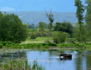
Nestled at the foot of the Selkirk Mountains just six miles east of Bonners Ferry, the 2,774-acre Kootenai National Wildlife Refuge provides diverse habitats for a large variety of wildlife including moose, elk, deer, bear, otter, bald eagles, and migratory waterfowl such as mallards, northern pintail, and teal.
And its provides excellent access to this wealth of wildlife, with a visitor center, 4.5-mile auto tour route and four fine hiking trails. One of those trails leads to Myrtle Creek Falls, an easy hike that the whole family can enjoy.
Established in 1964 as a migratory waterfowl refuge, the refuge provides respite for tens of thousands of waterfowl. It provides habitat for more than 220 species of birds, 45 species of mammals, and 22 species of fish.
Wetlands include open-water ponds, seasonal cattail-bulrush marshes, tree-lined ponds and rushing creeks; the refuge also has meadows, riparian forests and cultivated agricultural fields (for producing valuable wildlife food crops), interspersed in the valley bottom adjacent to the west banks of the Kootenai River.
Also visit the Myrtle Creek Falls while you are here. A short hike to a two tier water fall. See below for details.
 One of the largest rivers in the state, the Kootenai River flows into Idaho’s northern tip from Montana, through Bonners Ferry and then exits the state on our northern border with Canada. Idaho’s 66 river miles consist of a wide, slow-moving 47-mile section from Porthill to Bonners Ferry and 19 canyon miles upstream from Bonners Ferry to Montana. Anglers can find rainbow trout, cutthroat trout, bull trout, brook trout and mountain whitefish. About 20 miles east into Montana is the Kootenai Falls, one of the largest undammed waterfalls in the Northwest.
Parks, beaches and trails: The Kootenai is relatively inaccessible – making it a delightful destination for anglers or boaters who want to get off the beaten path. In Bonners Ferry there are public boat docks and a boat ramp. Just a few miles downstream from the town is the Kootenai National Wildlife Refuge, with an auto tour route and paths in the refuge alongside the river. In the town of Moyie Springs, 8 miles upstream, is the best river access at the Twin Rivers Resort, located at the confluence with the Moyie River and now operated by the Kootenai Tribe with a new and ambitious sturgeon and burbot fishery. The resort offers camping, picnicking, swimming and just lounging.
Boating: The river is navigable by motorboats along its length in Idaho. Downstream of Bonners Ferry the river meanders through the Kootenai Valley; most of the boating action is upstream in the scenic canyon. Rafters, canoeists and kayakers like this stretch; there’s no whitewater but advanced skills are advisable because the water is swift. River levels are controlled by the Libby Dam upstream in Montana, so boaters should be alert that river levels can rise or lower quickly.
Wildlife: The river canyon provides a year round home to white tail deer with frequent visits by mule deer, elk, and moose. The Kootenai National Wildlife Refuge is a splendid destination for wildlife lovers, where literally thousands of migratory water fowl can be spotted in season as well as upland game birds, hundreds of song birds and other wildlife.
Fishing: The Kootenai is notable for two fisheries of rare species, the white sturgeon and native Kootenai River burbot. The Kootenai Tribe has built a newly opened hatcher at Twin Rivers in the effort to restore these rare fish. For game fishermen, though the river provides good cutthroat and rainbow trout fishing as well as mountain whitefish and other species.
 Glacier National Park was established in 1910, covers about one million acres of land, and contains 25 “active” glaciers that move due to thawing and melting.
There are a number of beloved areas in Glacier National Park. “Going-to-the-Sun Road”, a 50-mile trek that provides some of the most amazing views in Montana, is Glacier National Park’s most popular destination. North Fork is only accessible by dirt road and has incredible views of some of the park’s many lakes, as well as a historic homestead site. Goat Haunt is a remote and tranquil location that crosses the US-Canadian border.
Glacier has numerous hiking trails and abundant fauna. Two Medicine is a more remote destination for the adventurous visitors who want a taste of true wilderness. Also found in Glacier National Park, Triple Divide Peak is situated at the hydrological apex of North America. Water can flow from here into the Pacific, Atlantic, and Arctic oceans.
 The big iron wheel is a relic from our industrial past, both the nation’s and the city of Bonners Ferry’s, where it once provided electricity to the quickly growing boomtown from 1906 to 1921.
 The Boundary County Museum is the anchor of the historic downtown business district of Bonners Ferry, retaining and exhibiting the heritage of Far North Idaho for both residents and visitors.
Open year ’round: October through April, 10 a.m. to 4 p.m. Fridays and Saturdays; May through September, 10 a.m. to 4 p.m. Tuesdays through Saturdays.
 Teascarlet Fine Art is the studio gallery of a local contemporary artist. This self-taught acrylic painter draws her inspiration from the scenery surrounding us in North Idaho, yet she defies the small-town artist stereotype both in style and philosophy. Her subjects range from precise flowers to evocative abstracts, and her exhibit history includes shows in Paris and New York as well as throughout the inland Northwest.
  Brush Lake Trail is on Forest Service lands about 30 minutes drive north of Bonners Ferry.
It offers a wonderful single track trail for hikers and mountian bikers. It’s an intermediate mountian bike ride with relatively small elevation gain that beginners might tackle to hone their skills.
The trail constitutes about a six-mile loop around small Brush Lake.
On a warm day, the lake provides for a refreshing dip; Brush Lake also offers fishing, though that’s best from a boat as much of the shoreline has difficult access. There is a small picnic and day use area.
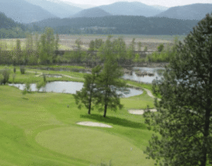 Mirror Lake Golf Course is a gem of a 9 hole course, located just one mile south of Bonners Ferry, and is enjoyed by golfers of all abilities. From the back tees the course measures 5,919 yards with a slope of 117 and a course rating of 68.4 for the men, while the forward tees are 5,256 yards with a slope of 123 and a course rating of 70.8 for the women. Par is 72 for both sets of tees.
Mirror Lake is player-friendly to the beginner, yet is a challenge for the low handicap golfer as well, with two sets of tees for the front and back nines. It has a diverse array of par 3s, 4s and 5s, along with stunning views of the Selkirk Mountains and the Kootenai Valley. The golf course features water hazards on both par threes as well as on 3 of the par fours. The course is in wonderful shape with fast and smooth putting greens.
If your game is in need of a tuneup, or you are a new golfer wanting to learn the game the correct way, Mirror Lake PGA Head Golf Professional Ralph Lotspeich is available to assist your needs. The golf course also provides a practice green, driving range, full service Pro Shop, snack bar, and cocktail lounge.
 Explore the International Selkirk Loop, designated one of only 32 All-American Road National Scenic Byways in the U.S., and discover the wonderful surprises that await you around every corner!
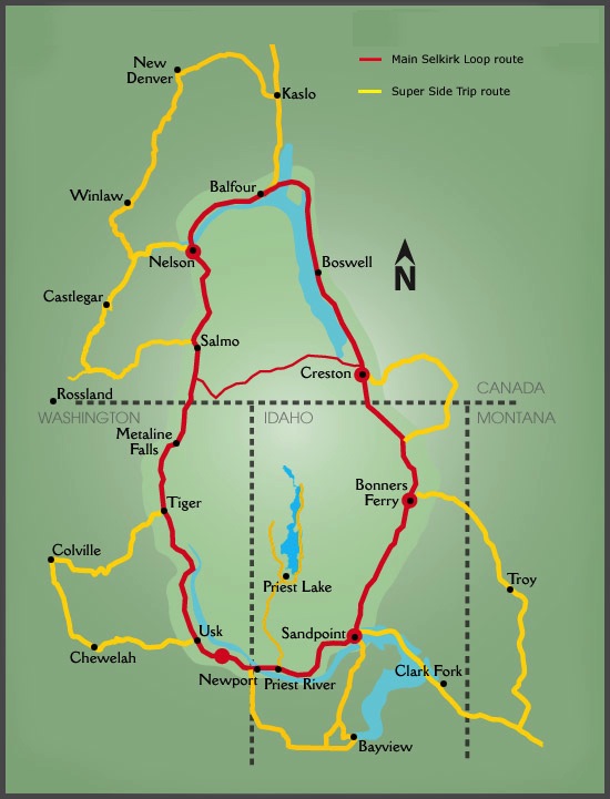 This 280-mile scenic drive is a grand loop through the Selkirk Mountains that takes travelers across the border into Canada, and The rewards are rich for those that do. Nearly the entire Loop follows rivers and lakeshores, which historically were used for transportation, by native tribes, explorer David Thompson, gold seekers on the Wild Horse Trail, and early settlers. Today the scenic Loop’s lakes, rivers and trails are a vast uncrowded playground with a myriad of opportunities for year-round recreation, scenic beauty and unique cultures in charming and authentic small towns. The main Loop includes a ferry ride across Kootenay Lake – the longest free ferry ride on the continent.
Among other distinctions, The Loop is the only National Scenic Byway that crosses an international border; it is also designated as one of the Top 10 Scenic Drives in the Northern Rockies.
Blue Lake RV & Cabin just so happens to be conveniently located right on the loop just south of Bonners Ferry
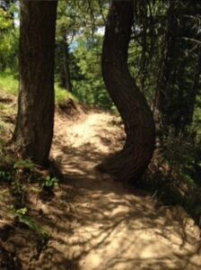 A fantastic network of trails in the immediate Bonners Ferry area for hiking and mountain biking. Visit their website for more details and maps.
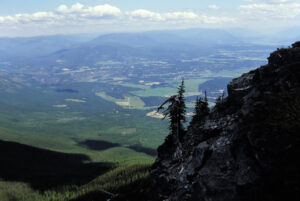 Beginning on a nice, flat bench on the ridgetop, Katka Peak Trail No. 182 makes a brief steep pitch up to another broad, flat bench before skirting around the south side of Clifty Mountain. But one must make the easy ascent to the peak of Clifty Mountain by simply climbing the relatively gentle slope from the west on a well-marked spur trail. The views from the top are magnificent up the Kootenai Valley and into the Purcell Mountains. Look for the towering summits of the Northwest Peaks Scenic Area to the northeast. The trail continues, mostly following the ridgeline up and over some minor knobs for another four miles out to Katka Pass. Trail 182 enters the pass, then swings out around the pleasantly open south slopes of Katka to a spur trail that climbs up the ridge from the east to the summit of Katka Peak, with its additional spectacular views of the surrounding countryside.
Details: 2 miles to Clifty Mountain; 6 miles to Katka Peak. Moderate difficulty.
Directions: From Highway 95 about seven miles south of Bonners Ferry, turn east onto Twentymile Creek Road 408. After about 10 miles on Forest Road No. 408 turn onto Road No. 274 for another four miles.
 Downstream from Libby, the Kootenai River enters a canyon and flows over Kootenai Falls, one of the largest free-flowing waterfalls in the northwest. The falls and surrounding area are considered sacred to the Kootenai Indians whose ancestors inhabited the region. A forest trail leads from the highway parking lot down to the Swinging Bridge and makes a nice hike that is not too strenuous. Kootenai Falls was the setting for the filming of the movie, “River Wild”. Location: US Hwy 2 between Libby and Troy, milepost 21.
Kootenai Falls on the Kootenai River, adjacent to U.S. Highway 2 between Libby and Troy, is a scenic attraction not to be missed. The calm river suddenly gathers momentum surging first through China Rapids and then over Kootenai Falls, dropping 90 feet in less than a mile. The main falls is 30 feet high and can be viewed from a “swinging bridge” that crosses the river. During the Depression, CCC (Civilian Conservation Corps) crews did a lot of work in the area constructing roads and bridges, including the first swinging bridge, across the Kootenai River.
The falls area is a sacred site to the Kootenai Indians who once called this area home. This was a place where tribal members communed with spiritual forces. In the early 1800s, David Thompson, a Canadian explorer and employee of the Northwest Company, travelled into the Kootenai river area and used the Kootenai River as a navigational guide through the area following Native American Indian and game trails. He portaged around the falls, following cairns — piles of rocks marking the trail — built by the Kootenai Indians.
The falls is accessed by a foot trail from the parking area next to the highway. The dirt trail winds through the trees and has frequent scenic vistas of the river. Benches are located at the top of the trail, and large boulders can be used for resting stops as the trail descends the hill to the river.
The trail goes over a special enclosed pedestrian bridge over double railroad tracks, then winds down to the Swinging Bridge which overlooks the falls.
While crossing the swinging bridge may not be for everyone, the views of the river from the trail make the hike well worth the time. Be sure to bring your camera!
The river, falls and surrounding rock cliffs create a unique place that commands a feeling of the power of nature to all who visit. In the winter, the falls transforms into a spectacular cascading iceflow, and bald eagles can be seen perched in the bare cottonwood trees along the water’s edge.
 An enjoyable 9 mile drive from Bonners Ferry will take you to beautiful Snow Creek Falls. There is a large pullout for parking on the left just before the trailhead.
This short, 1 mile nature hike can be enjoyed by the whole family and those who do not want to hike 10 miles into the back country to find beautiful waterfalls. The waterfalls are fed by an alpine lake and several small cold creeks. The bridal veil fall at the upper falls is the largest and cascades more than 30 feet. The lower falls has multiple cascades.
The waterfalls are a lush green scene of moss and other flourishing vegetation encouraged by mist and moisture. I enjoyed the up-close access, close enough to feel the spray on my face.
From the trailhead, I hiked the trail as it made a gradual descent into the Snow Creek drainage. I noticed the trail started with Ponderosa pines and descends through a dry open hillside to old growth cedar and hemlocks. Seasonal wildflowers abound along the path.
I was pleased to see that the trail was well-maintained, with benches along the way, and boardwalks crossing small trickling brooks and streams. There is an intersection at 0.6 mile, a left will take you to the lower falls and a right turn will lead you to the upper falls. The falls are particularly impressive during spring runoff, with year around flows each are worth visiting anytime of the year.
Snow Creek Falls is west of Bonners Ferry on the Riverside road, approximately 5 miles to the Kootenai National Wildlife Refuge and then turn left onto Lion’s Den Road. Follow Lion’s Den Road for 2.8 miles and then turn right onto Road #402 (Snow Creek Road) and follow it for 1.2 miles to the trailhead on the left. The trail is primarily used for hiking, walking, nature trips and birding and is best used from April until October. Dogs are able to use this trail but must be kept on a leash.
Although I do not hike as much as I should, hiking exercises almost every part of the body: legs, knees, ankles, arms, hips, abdominals, shoulders and neck. What I like about hiking other than physical activity is that it also exercises the mind and nourishes the imagination. It creates awareness in your eyes, nose, ears and the rest of your senses. Hiking is a good way to leave the everyday pressures behind and recharge your battery. There is no better place to hike and enjoy the scenery than Boundary County.
Other beautiful falls in Boundary County include Copper Falls, Moyie Falls, Smith Creek Falls, and Myrtle Creek Falls.
During the summer months I would encourage scenic hikers to bring bug repellent while viewing these beautiful trails and waterfalls … oh, and bear spray! Remember it is huckleberry season, be sure to bring a sack or bucket to put the purple gems in — or do what I do best, just eat them.
-Don Bartling
 Spruce Lake, nestled at the foot of a steep 6,000 foot cliff known as Ruby Ridge, is a pristine six acre, high-altitude lake at the end of a 0.6-mile hike. This small alpine lake and associated trail are great for all hiking levels. Keep an eye out for the chance to see moose, deer or elk, and don’t forget to bring your fishing rod for a chance to catch some rainbow trout, or bring your camera and get a pic of an Osprey doing the fishing.
 Copper Falls trail is mild and well maintained and has several informative interpretive signs along the way. The trail is only three-tenths of a mile, to the viewing area, but is steep at times. Falling 160 feet, Copper Falls is well worth the short but vigorous hike.
If you want to extend your hike, keep following the Loop Trail down into a ravine through large trees then back up the mountain to where you started.
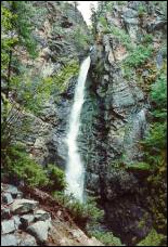
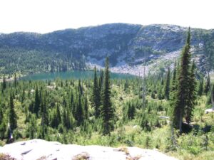
 Myrtle Creek Falls is located inside the Kootenai National Wildlife Refuge just across the street from the Refuge Headquarters. After crossing the bridge over Myrtle Creek, an easy quarter mile trail gradually leads you up to the falls viewing area via several switchbacks.
One of the more spectacular and photogenic falls in the area, Myrtle Creek Falls has an upper and lower falls that drop 100 feet with a pool in between.
You’ll have to leave your pooch at home for this one as there are no dogs allowed on this trail.
Roman Nose Lakes is an easy, well-traveled trail system that sends hikers into the heart of some of the most beautiful terrain in the Selkirks. Nested beneath the towering presence of 7,260-ft Roman Nose Peak, the trailhead offers hikers access to three different lakes and the potential for an off-trail scramble with stunning views of the Selkirk Crest from the top of the peak. With jagged rocky peaks and thick forests surrounding the area, this trek is one you do not want to pass up.
From the parking lot, access to the beautiful lower lake is a simple stroll across a boardwalk. Roman Nose has three lakes to chose from, each providing different features. The lower lake is easily accessible and does not require any hiking. The middle lake has more fish than you’d imagine, crystal clear waters, and a beautiful waterfall. And the upper lake has big fish, incredible views, and glaciers surrounding. If you plan to go to one of the two upper lakes, it is about a 60 minute hike.
From the trailhead, cross a footbridge to begin the gentle climb toward the two upper lakes. Climb through subalpine firs and granite rocks to reach the first junction on your right to a spur trail that offers spectacular views of the lower lake and its glacial cirque. Bear left and continue on to another junction to reach a scenic interpretive loop that switchbacks to 6,410 ft and offers captivating views of the lower lake.
To take a more direct route to the backcountry lakes through a beautiful forest in recovery after the Sundance forest fire of 1967, continue on Trail 165.
Driving Directions to Roman Nose: (1.5 hour drive from Naples, ID)
From US 95/2, turn onto Deep Creek Loop(Old Hwy 95). Turn onto Lions Den Rd. (left if coming from the south, right if coming from the north). Drive 2 miles to a Y in the road. Stay left onto Snow Creek Rd(Forest rd 402). Drive 9.5 miles on Snow Creek Rd(402), passing the turnoff to Cooks Pass Rd, and bear left onto Rd. 1007. Drive 7.3 miles over Caribou and Ruby Passes and turn right toward Roman Nose Lakes on Rd 2667. Go 0.5 mile, passing the campground turnoff, to the trailhead near Roman Nose Lake 3.
- Mugsy’s Tavern & Grill
- Our favorite go to spot in Bonners Ferry
- Mi Pueblo Mexican Restaurant
- Second go to spot. Surprisingly good Mexican food for being this far north.
- Kootenai River Brewing Co.
- Feist Creek Restaurant
- Nice destination restaurant with a waterfall and a pond full of huge trout.
- The Rusty Moose Tavern and Grill
- Goat Mountain Pizzeria
- Soulshine Bistro
- Pizza Factory
- Daily lunch buffet only $6
- Simple Simon’s Pizza
- Delivers to Blue Lake!
- Two Tones Cafe
- Chic-N-Chop
- The Badgers Den
- Springs Restaurant
- Inside the Casino. Only restaurant on the Kootenai River.
- 3 Mile Cafe
- Bread Basket Bakery
- 9B Trails
- A number of hiking and cycling trails in the immediate Bonners Ferry area.
- Snow Creek Falls
- Myrtle Creek Falls
- Copper Falls
- Kootenai Falls & Swinging Bridge
- Roman Nose Lakes
- Clifty Mountain & Katka Peak
- Brush Lake
North Idaho offers great fishing opportunities wherever you turn. From 20 lb. rainbows in Lake Pend Oreille to freshwater lingcod (burbot) in the Kootenai river. Depending where you fish you can find Rainbow, Brown, Cutthroat, Brook, Lake and Bull Trout, Kokanee Salmon, Sturgeon, Burbot, Mountain and Lake Whitefish, Bass, Bluegill, Crappie, Perch, Walleye and Northern Pike.
Some local spots to try your luck are:
- Right here at Blue Lake! (catch and release only please)
- Kootenai River
- Moyie River
- Pack River
- Deep Creek
- Myrtle Creek
- Lake Pend Oreille
- Smith Lake
- Brush Lake
- Dawson Lake
Where there’s fishing opportunities, there’s boating opportunities! The nice thing about Boundary County is that all lakes are electric motor only, so you’ll be sure to enjoy a peaceful paddle wherever you go. Some places you’ll want to consider:
- Right here at Blue Lake! (Kayaks available for rent)
- Kootenai River (check flows, early season may be dangerous)
- Paddle from Bonners Ferry to Canada, or start from the Montana border and linger through a 2 day class 1&2 into Canada.
- Moyie River
- Pack River
- Deep Creek
- Myrtle Creek
- Lake Pend Oreille
- Smith Lake
- Brush Lake
- Dawson Lake
Just down the road from us is Mirror Lake Golf Course. A beautiful 9 hole course you won’t want to miss.
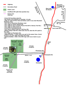
US Forest Service ORV park is only 3 miles away on prospect road. Click HERE for full size map.
- Right here at Blue Lake RV Resort!
- Kootenai National Wildlife Refuge
- Any of the many small lakes in the area including Brush Lake, Smith Lake, Dawson Lake
- Kootenai River
- Lake Pend Oreille (Pronounced pond-a-RAY)
- Deep Creek
Up for a game of bowling? Stop by AJ’s Lanes in Bonners Ferry.
- Farmers Market
- Every Saturday in the Summer
- Kootenai River Run
- Mid to late June, check link for this years dates
- Kootenai River Ride
- Mid September
- 4th of July Parade
- July 4th of course!
- Kootenai River Days
- Typically the second week of July, check the Chamber of Commerce events page.
- Boundary County Fair
- Mid august
Visit Toasty Mobile Saunas in Sandpoint for Saunas, Cold Plunges and Mineral Hot Tubs.
www.toastymobilesaunas.com
Also, keep an eye out for weekends that they set up their sauna here, at Blue Lake RV Resort and get the best of both in one location.